Dirt road on Great Northern Highway
Submitted: Tuesday, Mar 21, 2023 at 18:47
ThreadID:
145435
Views:
2558
Replies:
4
FollowUps:
0
This Thread has been Archived
Member - John H90
Noticed this on the new 2023 maps, this is sealed road on the 2021 map.
Is this the section that was damaged by flooding a few months ago ??,
John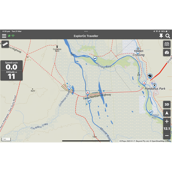
Pandanus Park
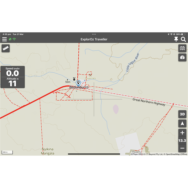
Bedunburra
Reply By: Rod N - Tuesday, Mar 21, 2023 at 19:35
Tuesday, Mar 21, 2023 at 19:35
Have a look at the WA main roads site.
WA Main Roads
AnswerID:
643111
Reply By: Rob J8 - Tuesday, Mar 21, 2023 at 21:03
Tuesday, Mar 21, 2023 at 21:03
The
bridge across the
Fitzroy River at Fitzroy Crossing has been damaged beyond repair and a new
bridge will be built starting when the river subsides. Apparently it will take years to build so a new low level crossing will be constructed also when the river subsides. In the old days the only way across the Fitzroy was on a concrete low level crossing that went under when the river flooded. People used to be stranded for weeks waiting for the river to drop. The
bridge was supposed to make the Great Northern Highway along with others an all weather Highway. The new
bridge will have to be quite a bit higher than the old one. From what I've seen on the GWN 7 news a barge is transporting single vehicles and people across at the moment.
Since posting this information I have read in a post elsewhere by the Shire of West
Kimberley that the low level being built could be ready by late May. I still wouldn't plan my trip on might be.
AnswerID:
643113
Reply By: Member - kimberleybloke - Wednesday, Mar 22, 2023 at 13:49
Wednesday, Mar 22, 2023 at 13:49
This map version seems to blank out the sealed road when it is closed, (i.e. by MRD) , the sealed road is still there, although the 10km at Willare that washed away is still showing as a sealed road.
Gibb River Road also disappears at Meda Stn turnoff, the problem is that the road is open to all traffic now through Willare and the GRR closed section now starts at Lennard River
Bridge, (has done for weeks now), system appears slow to update road conditions if in fact this is what it is.
AnswerID:
643129
Reply By: Member - John H90 - Wednesday, Mar 22, 2023 at 15:04
Wednesday, Mar 22, 2023 at 15:04
Don’t get me wrong I think Michelle & David have done a fantastic job with the 2023 maps and the App in general but I’m not sure about road conditions been added to a map based app.
I’m happy to have road conditions added to ExplorOz app but it’s a lot of work monitoring road conditions all over Australia and to be consistent and have all road closures and conditions covered.
If we are gong with a road condition App, I would prefer that the roads remain as they were before the conditions being reported and have a warning on the road where the problem is and what the condition is.
At the moment the Fitzroy
river crossing bridge is damaged and closed, if I try to setup a route with the app it will divert around it.
Which is fine but I’d rather have a pop up telling me of the
bridge closure and asking me if I want to divert around or not, if we’re moving to the Map and Road conditions App.
At the moment I’m planning on my first Hi-way 1 trip around Oz and there’s no Trek on ExplorOz App that follows Hi-way 1, so I’m creating one.
I would normally plan a route on the app and then use road condition info on state Government web sites or clubs like RACQ in Qld for road conditions etc just before we leave and during the trip.
I’m not sure which way to go staying with a map app only app or adding road conditions and following through with updating the map all year round to be consistent.
I feel consistently is very important with a mapping app.
Theses are my
views only and don’t wish to offend anyone just wanted to add my 2 cents.
AnswerID:
643131